Climate Map:

Major Climate Types:
Austria: Drier Summer
Belgium: Semi-Arid
France: Semi-Arid
Germany: Semi-Arid
Liechtenstein: Drier Summer
Luxembourg: Semi-Arid
Monaco: Drier Summer
Netherlands: Semi-Arid
Switzerland:Semi-Arid
Belgium: Semi-Arid
France: Semi-Arid
Germany: Semi-Arid
Liechtenstein: Drier Summer
Luxembourg: Semi-Arid
Monaco: Drier Summer
Netherlands: Semi-Arid
Switzerland:Semi-Arid
Overall, Western Europe has a humid climate due to its proximity to the Atlantic Ocean. Mediterranean climates, at lower temperature-altitudinal zones, have hot, dry summers and cool, damp winters, and they also prevail in this region. Countries close to the ocean, such as Spain, France, Ireland, Portugal, Italy, and Greece, among others, have higher precipitation levels. North of the Alps, a marine climate dominates, with relatively cold, moist winters, and wet, cool summers. Austria and nearby countries located inside the Alps mountain range receive cold, wet winds in the winter and only relatively warm summers due to the highest altitudes existing here. Southwestern Europe is generally warmer than Northwestern Europe due to the greater proximity to the Equator.
Most Western European agriculture occurs in Southern France and Northern Spain due to more moderate, warm climates. In Mediterranean climates, people learned to grow crops such as wheat, which grows during the moist, mild winter, and deep-rooted vines and trees, such as olives and grapes, which thrive in warmer areas. North of the Mediterranean, especially in the Alps of France, Switzerland, and Austria, and along the North and Baltic Sea shores, populations found it difficult to grow crops, so dairy farming became the alternative for these higher temperature-altitudinal zones where very cold temperatures exist. Between the two aforementioned regions, a third, more moderated climate exists. Settlers here adapted to raising mixed livestock and farming a variety of crops as the result of very cloudy, cool climate patterns.
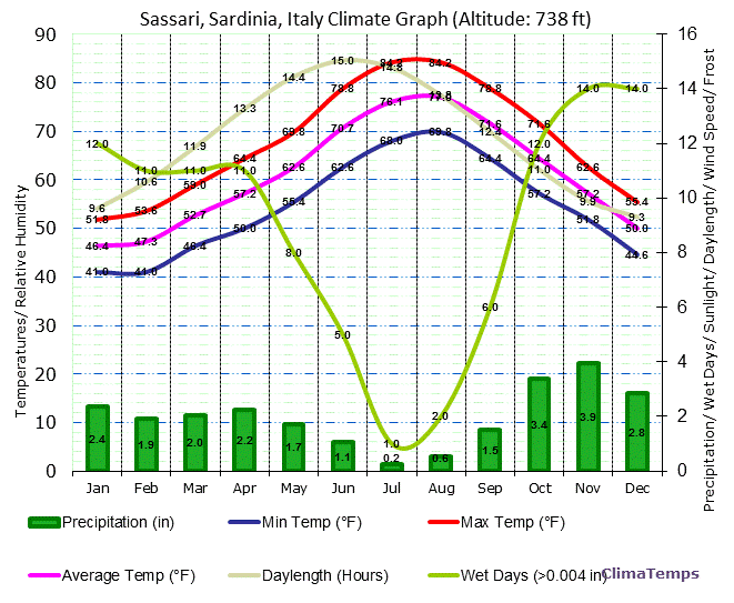
Sardinia, Italy is an example of a city located in the Mediterranean climate region. The hot, dry summer is evident in the climograph where the green precipitation bars dip down in the summer months, and the pink average temperature line rises around the middle of the year. The cool, damp winters are evident in the manner in which the green precipitation bars rise as winter approaches and stay relatively high in December and January, and the pink average temperature line dips progressively into the winter months.
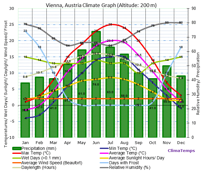
Vienna, Austria is an example of a city located in the Alps climate region. The mildly warm summers are evident in the way the pink average temperature line only ranges from 60-70 degrees F from June through August. Additionally, the cold, wet winters are evident in the high precipitation levels (compared to other regions) indicated by the green bars and the very obvious drop of the pink average temperature line during the winter months.

Oslo, Norway is located North of the Alps. Relatively cold, moist winters are shown in the climograph by the high precipitation levels (compared to other regions) shown by the green bars and the large dip in the pink average temperature line in the winter months. Evidence of wet, cool summers is present in the way the green precipitation bars and the pink average temperature line rise significantly from June through August.

Early fall in Frankfurt, Germany, located north of the Alps.

An Austrian lake town in winter.

An olive farm in Provence, France.
